National Parks - Central Valley
As you descend into the Santamaria International Airport (SJO) in the Central Valley of Costa Rica you can start your sightseeing experience from the airplane as you fly over the magnificant volcanoes Poas and Irazu. On a clear day you can easily see the greenish yellow crater lake surrounded by an expanse of rainforest, complete with mist and clouds associated with these huge marvels of nature. It is these marvels that also give the Central Valley Region its mineral rich soil which in turn produces some of the most beautiful flora you can imagine. It is so lush and plentiful all year round that a variety of these unique plants are shipped to many foreign countries and end up in your neighborhood florist shops. Costa Rica is also widely known for their coffee products which are rich in flavor and have an aroma that invites you to have another cup. These are but a few examples of the products that these volcano filled mountains of the Central Valley are responsible for but seeing them in person is an adventure you do not want to miss.
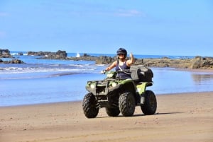
If your stay in the Central Valley is a short one, many of the National Parks are located very close to one another so it is quite easy to complete tours or trails in more than one park before the evening sets in. You will also find a variety of National Reserves surrounding many of the National Parks making it easy to see several sights in the same day. While San Jose is a short driving distance to any of the National Parks located in the Central Valley, there are a variety of quaint eco lodges, hotels and other accommodations that are centrally located to the park entrances. The accommodations tab of our web sight will help you find close accomodations for whatever you may have in mind while you visit exciting Costa Rica.
To grasp the "awe" of these geothermal wonders, see some amazing wildlife, flora, fantastic waterfalls and more, make sure to visit the National Parks scattered throughout the Central Valley.
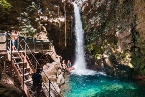
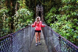
Baurllo Carillo National Park: Twenty miles northeast of San Jose you will find Baurilo Carillo National Park which boasts 118,000 acres of cloud and natural rainforest. There are several dormat volcanoes and crater lakes to explore as you take off on one of the many trails that wind through this magnificant park. Experience breathtaking views as you take the gondala trail on the eastern end of the park which gives two distinct views of the rainforest canopy and valley surrounding it. The park offers many short trails that are perfect for the family to trek to the waterfall platforms which give you the picture perfect view of these amazing cascades. There are picnic areas and facilities within a short distance of these trails so packing a lunch and taking in the scenery and wildlife is a great way to spend the day. There is a large selection of hotels and restaurants a short drive from the park entrance.
The experienced hikers have trails over 30 miles long that wind from Barva to La Selva which can amount to a 3 to 4 day hike. If you choose one of the longer trails notice the difference in the surrounding flora and trees as you gain altitude. There is a 10,000 feet elevation difference from the top to the bottom and the sights are amazing so bring your camera and have something to remember this fabulous journey. When hiking the longer trails, proper gear, food and water should be considered as there are no facilities or ranger stations along a major portion of them. It is also recommended for your safety to inform a park ranger that you will be hiking the extensive trails. No accomodations are available inside the park but its central location gives the visitor many choices within miles of the entrance. Check our accommodations tab for the closest hotel for this sight.
| Area | 118,000 acres | |
| Max. Elevation | 9,532' above sea level | |
| Temperature | Ranges from 35ºF (in the high altitudes) to 90ºF | |
| Precipitation | 180 inches annual average | |
| Location | Central Valley, 20 miles northeast of San Jose | |
| Created | 27 April 1978, with several later additions |
National Reserves and Refuges around Baurilo Carillo National Park include Central Volcano Forest Reserve, La Selva Protected Zone, Jaguarundl Wildlife Refuge
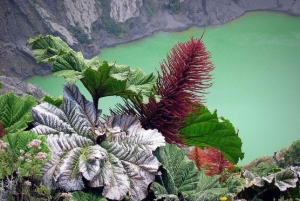
Irazu Volcano National Park: Thirty miles east of San Jose and 11,000 feet above sea level you may have seen the bright greenish yellow waters of Diego de la Haya crater lake as you flew into the International Airport. The crater lake is a part of Irazu Volcano National Park and Irazu is the highest in Costa Rica perching itself 3,432 meters above sea level. Considered the most active volcano in the country, Irazu last erupted in 1963-1965 which left the vegitation on the east side of the volcano devestated. Currently there is a reforestation project going on in that area which has made immense progress over the last few years but remains a slow task to bring back the natural flora that once covered the ridge. The lake keeps the same greenish yellow color all year long as the rainfall flows over the mineral rich walls and into the lake. You get a great view of the depth of the crater from a viewing platform well above the perimeter. Check here for the closest hotel for this sight.
To the southwest of the volcano the Ricardo Jimenez Oreamuno Recreation Area is a great stop close to the park as hiking trails and camping is available. There is a vistor center with a small cafe at the viewing platform inside the park but no camping or accomodations are currently offered. Check for the closest hotel for this attraction.
| Area | Approx. 6,000 acres | |
| Max. Elevation | 11,260' above sea level | |
| Temperature | 40ºF annual average | |
| Precipitation | 80 inches annual average | |
| Location | Central Valley Region / Cartago Province | |
| Created | 9 August 1955 |
National Reserves and Refuges around Irazu National Park include Central Volcanic Forest Reserve, Guayabo and Guayabo National Monument.
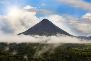
Turralba Volcano National Park: Known for the largest craters in Costa Rica, Turrialba Volcano National Park is located 40 miles east of San Jose and only a hop, skip and jump from Irazu Natinal Park. It makes it an ideal route to see the sights of both in one day and still have plenty of time to return to San Jose. At 10,985 feet above sea level it has three distinctive craters that are deep and well forested. The center crater is the deepest and most active, pouring steam and vapors into the atmosphere each day so it is closely monitored by government agencies. Turrialba is a stratovolcano or "composite" volcano because of its conical shape built up over many layers of hardened lava, pumice and volcanic ash. The last major eruption took place in the late 1860's but fumarole activity still takes place at the summit craters. Check here for the closest accommodations to this attraction.
From the small cafe at the park station you can take a trail that leads you up to the crater viewing platform. There are no other facilities or accomodations in the park at this time.
| Area | Approx. 3,900 acres | |
| Max. Elevation | 10,958' above sea level | |
| Temperature | 60ºF annual average | |
| Precipitation | 120 - 150 inches annually | |
| Location | Central Valley Region / Cartago Province | |
| Created | 30 July 1955 |
National Reserves and Refuges around Turrialba Volcano National Park include Rincon de la Vieja and Miravalles Volcano.
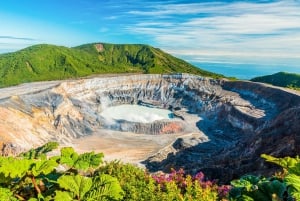
Poas Volcano National Park: Forty miles north of San Jose lays the amazing Poas Volcano National Park, a glorious display of geothermal activity that help form Costa Rica long ago. In between clouds of steam, mist and shooting geyers the visitors to this park can see old lava flows frozen in time, and the worlds largest active crater. The colorful summit craters are a popular attraction and can be reached by vehicles instead of the lengthy walk to park stations. Poas is another stratovolcano that lies between to large calderas. The southern crater contains a crystal clear lake called Botos which contains cold waters and has not erupted for many decades. The northern crater contains warm, acidic water and erupts with geyerlike displays of water from the lake periodically but has not had a major eruption since the 1950's. Bring warm clothing when visiting the park as at these altitudes the temperatures often fall below freezing and are quite common for the area. There are three trails that are short and an easy hike for all members of the family and the perfect setting to obtain some great pictures to carry home. Check here for tours offered for this attraction.
On the lower slopes of Poas you will find an array of fruit and floral farms, mild temperatures and grazing cattle. There is a modern visitor center and museum with exhibits that detail the geothermal activity of this amazing force of nature. No accomodations or camping are allowed in the park at this time. Check here for the closest accommodations to this attraction.
| Area | Approx. 16,000 acres | |
| Max. Elevation | 8,900' above sea level | |
| Temperature | 45ºF - 70ºF | |
| Precipitation | 140 inches annual average | |
| Location | Central Valley Region / Alajuela Province | |
| Created | 25 January 1971 |
National Reserves and Refuges around Poas Volcano National Park include Grecia Forest Reserve, and Bosque Alegre Wildlife Refuge.
Tapanti National Park: The last park of the Central Valley and greatest distance from San Jose is Tapanti National Park, an outdoor paradise if you don't mind getting a little wet. This park sits in a region that gets more rainfall than any other area of Costa Rica forming several natural eco systems, filling the many rivers that run through the tropical scenery which is the primary source of fresh water for the San Jose, Escazu and neighboring population. The park borders the Rio Grande de Orosi River on one side and the Talamanca Mountain range on the other giving ideal conditions for an array of beautiful waterfalls, swimming holes, fishing, birdwatching and amazing wildlife. The perfect day for this park is to head out early, enjoy the hiking trails to some spectacular scenery and wildlife, stop for lunch at one of the picnic areas and complete the day with a swim in one of the many river pools. The water is a little on the chilly side but very invigorating once you take the plunge.
There are two park stations inside the park but no accomodations are offered at this time. If you plan on fishing you will also need to acquire a fishing license which can be taken care of at either park station. Check our accommodations tab for the closest hotel to this attraction.
| Area | Approx. 144,058 acres | |
| Max. Elevation | 8,397' above sea level | |
| Temperature | 45ºF - 70ºF | |
| Precipitation | up to 280 inches annual average | |
| Location | Central Valley Region / Cartago Province | |
| Created | 1 February 1982 |
National Reserves and Refuges around Tapanti National Park include Rio Macho Forest Reserve, Paramo Wildlife Refuge, Los Santos Forest Reserve and Cerro Las Vuellas Biological Reserve.
There are 17 National Parks in Costa Rica located throughout any region you want to travel. Experiencing these National treasures first hand will be a memorable part of your visit to Costa Rica as it is in these parks that the real magic of the country comes alive. Wildlife florishes in these natural habitats and it is with great pride that the country works diligently to maintain these parks in their pristine condition. Entertain yourselves along pristine beaches, active volcanoes, surging rivers, majestic mountains and more as you visit these diverse National Parks and have the experience of a lifetime.